


Have you said to yourself "this summer seems to be hotter than it usually is?" Well, you'd be correct.
We have been stuck in a very warm and muggy pattern here across the Tri-State over the last few weeks and that has led to one of the warmest starts to Meteorological Summer in recent history.
We are nearly halfway through meteorological summer, so lets take a look at how it stacks up so far compared to past years.
For clarity, meteorological summer is defined as all 92 days spanning from June 1st through August 31st.

Our average temperature of 75.7° since the start of June, puts the first 42 days of Summer 2022 as the 25th warmest on record in Cincinnati. What makes 25 impressive is that this list of data spans 150 years, dating back to 1872!
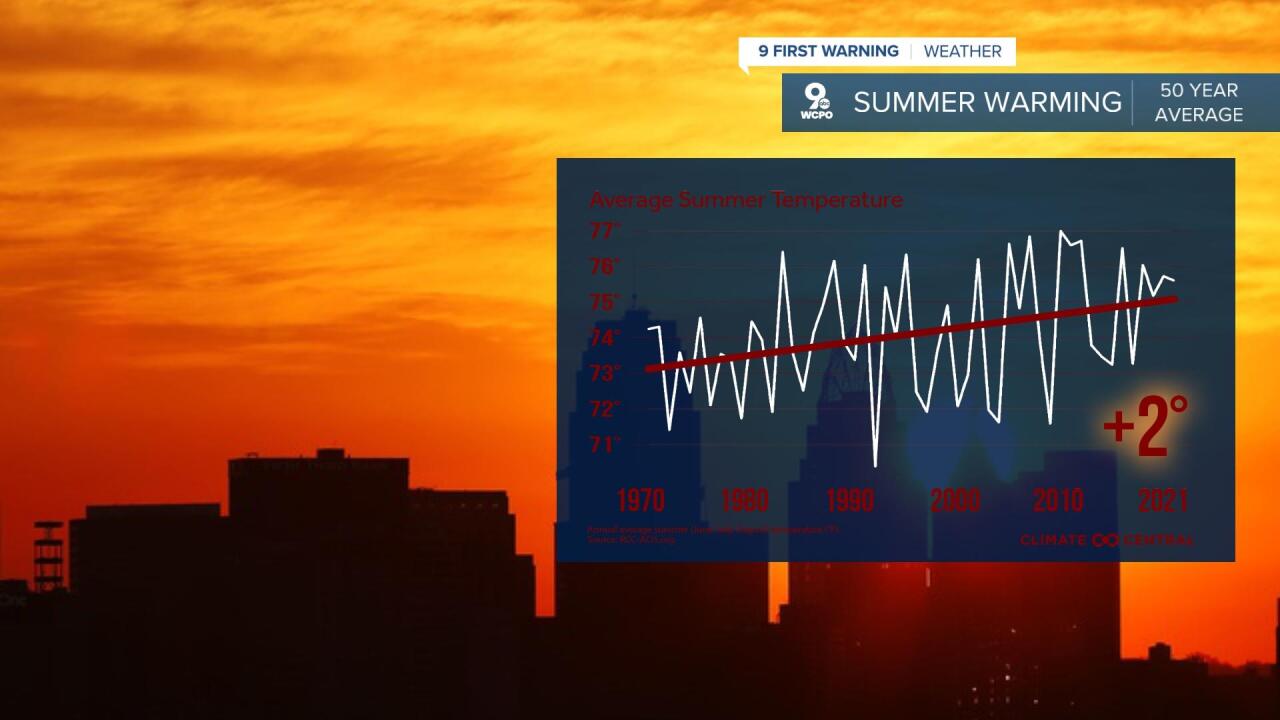
However, if you scale that data to only include the last 50 years (1972 to present), this summer is fourth on the list, only behind 2018 (76.5°), 1991 (76.3°), and 2012 (76.0°), one of the warmest summers in recent history.
As stated, the first 42 days of summer has resulted in an average temperature (combination of our high and low temperatures) of 75.7°. The "normal" average for that same time span is 73.4°.

That 2.3 degrees above average lines up with how the last 50 years has trended. Over the last 50 years our average summer temperature in Cincinnati has increased by 2.0-degrees. That is detailed in the graph below from our friends over at Climate Central.
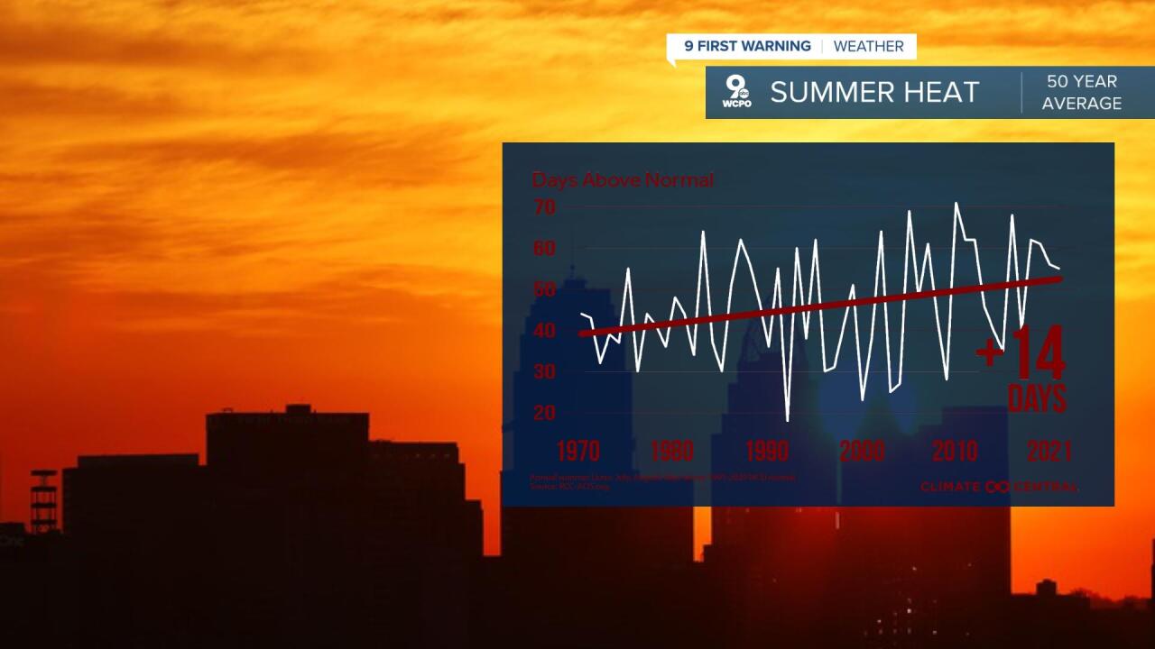
With all that warmth and humidity, it can be assumed that we have seen our fair share of days with above normal temperatures. So far, 2/3 of our days this summer have finished with temperatures warmer than normal, with 18 in June and another 10 so far in July.

With 50 days remaining in summer, if we continued on the 67% clip, we would finish with 62 out of 92 totals days above average, which would be close to the most we have ever recorded. As you can see in the graph below from Climate Central, our days above average have grown over that same 50 year span. Back in the early 1970s, we only saw 30 to 40 above average summer days, while the past decade that number is closer to 50. That is a 50-year increase of 14 days per summer. For perspective, the summer of 2021 produced 55 days above normal.
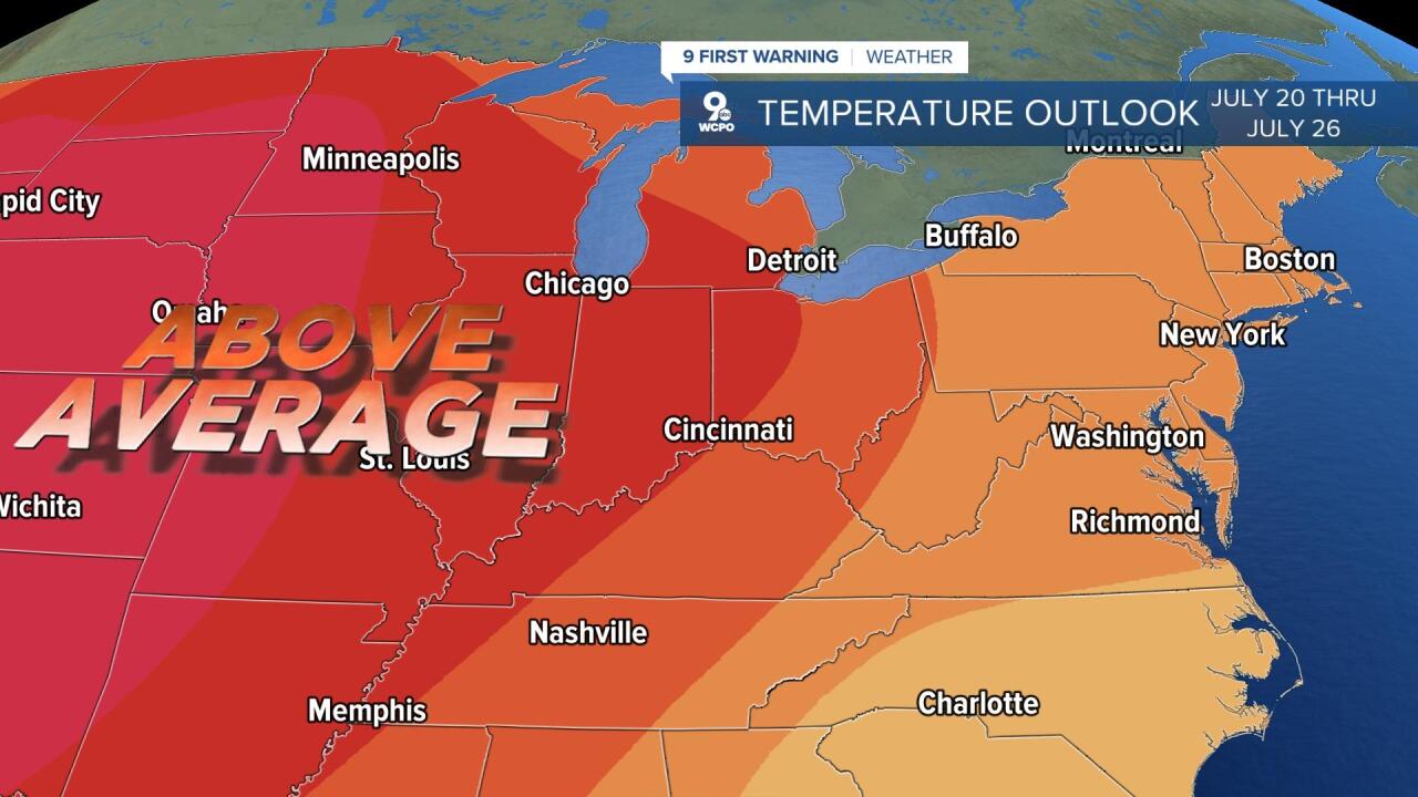
While the forecast the next few days looks to be seasonable, the extended forecast is trending towards warmer than normal temperatures returning. The Climate Prediction Center's 8- to 14-day temperature outlook, shows a strong likelihood that we will see warmer than normal temperatures for the second half of July.
The remainder of July is usually one of our hottest stretches of the year, and then we move into the month of August. August is generally our second warmest month of the year, with an average monthly temperature of 75.0°F. If we continued the trend of staying around 2.3 degrees above normal through the rest of the summer, it would place us at 17th all time and would go down as the second warmest summer so far this century.
