


Hurricane Helene is the main weather headline for much of the country today and that includes us here in the Tri-State. Rain from the storm is already starting to move in and it will only intensify from here as the center of the storm moves inland overnight. Because of this, Friday is a 9 First Warning Weather Alert Day.
Rain turns much more widespread through the overnight hours as the outer bands of Helene push north into the Ohio Valley. Steadier rain will be with us as we head into the morning on Friday, which could impact your morning ride to work. This will likely lead to some slowdowns and delays, so plan for a much longer drive.
Rain is likely nearly the entire day on Friday, but the heaviest is looking to be between 10 a.m and 5 pm. Periods of torrential downpours will be possible, especially with a few embedded thunderstorms in the afternoon hours.
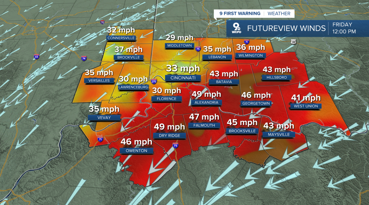
Another big impact for us on Friday will be the wind. A Wind Advisory has been issued for the entire Tri-State which will be in effect from 10 a.m. Friday through Midnight Saturday morning.
9 FIRST WARNING: A Wind Advisory is in effect for the entire Tri-State on Friday as the center of Hurricane #Helene nears. Wind gusts Friday could possibly be as strong at 50 to 55 mph @wcpo#WCPO #CincyWX #ohwx pic.twitter.com/3db0WxgRZE
— Brandon Spinner WCPO (@wxSpinner89) September 26, 2024
Through the morning our winds are going to increase from the northeast up to 20 to 30 mph. Through the midday hours, as the center of Helene is closest, the wind gusts could be as strong as 45 to 55 mph. With this, scattered power outages will be possible.
The worst of the rain should begin to taper off into the evening on Friday, subsiding around 6 to 7 p.m from east to west. There will still be scattered showers, but the rain looks to let up in time for the Friday night football games.
More scattered showers will return on Saturday. While they won't be as heavy, they will be widespread at times, and consistent. This will just add to the saturated soils and could impact some areas with localized flooding. Either way, the clouds will be with us most of the day, which means our highs on Saturday only hit the upper 60s and low 70s.
Rain is starting to fall in parts of of the Tri-State and will ramp up on Friday. By the end of the weekend some areas will pick up 2-4 inches. Flooding may be a concern especially in intense downpours on Friday#WCPO #CincyWX #ohwx pic.twitter.com/B5pSli8nTH
— Brandon Spinner WCPO (@wxSpinner89) September 27, 2024
All said and done, we could be looking at significant rainfall totals. Totals will taper off the further north you get of the Ohio River . However, most areas should be between 2" to 3" of rain, with locally higher numbers close to 4 inches the further south and west you go.
THIS EVENING
Cloudy sky
Isolated light showers
High: 72
THURSDAY NIGHT
More numerous showers
Staying mild
Low: 67
FRIDAY
Rain likely, windy conditions
A few storms, heavy rainfall
High: 71
FRIDAY NIGHT
Isolated showers
Overcast, breezy
Low: 64
9 First Warning Weather 24/7 Livestream
==========
- Interactive Radar: Track weather to your doorstep
- Sign up for severe weather email alerts
- Check latest school closings and delays
- WCPOtraffic updates
- Metro bus detours and updates (or call the hotline at 513-632-7538)
- Latest power outages from Duke Energy
- Flight cancellations and delays from CVG, other U.S. airports
