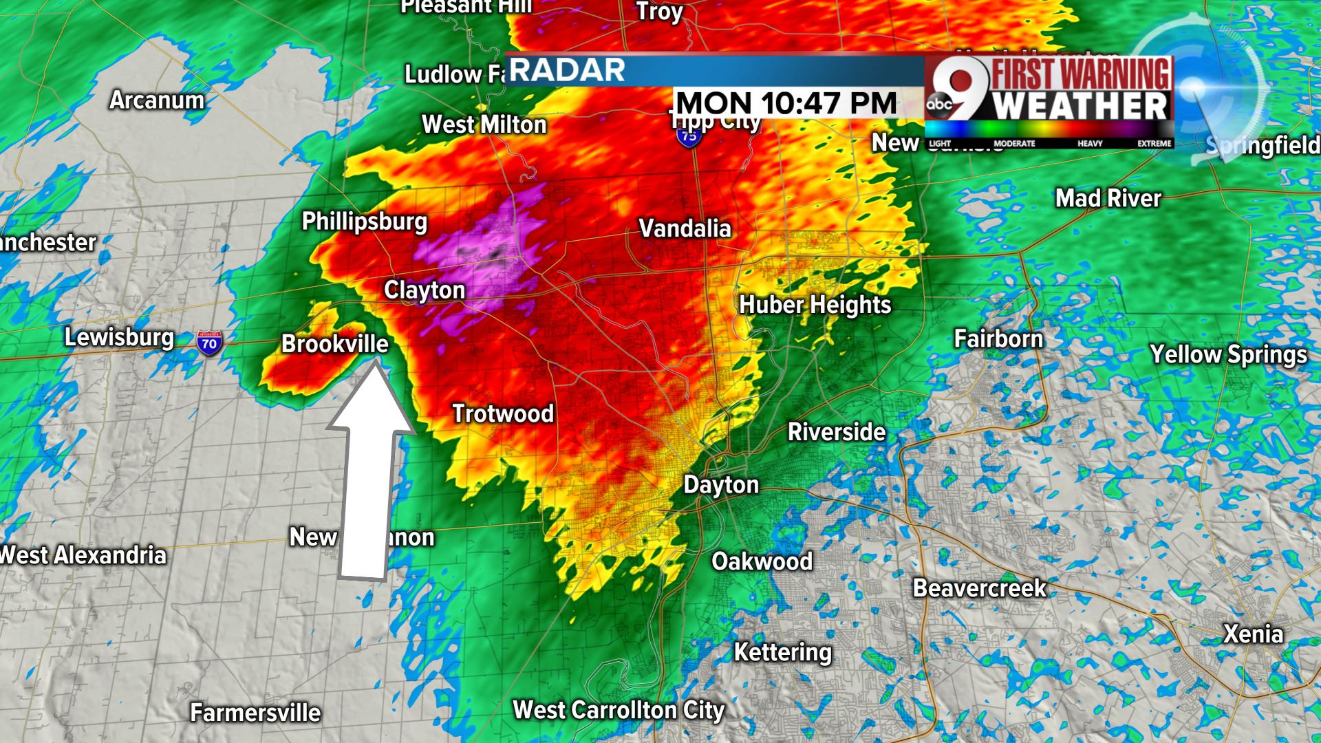
Severe storms entered Ohio at about 10 p.m. Monday, having already produced damage to the west in central Indiana. It was clear on radar that the storms moving in would lead to damage over the next two-four hours and that's exactly what unfolded over the Miami Valley.
Now, the National Weather Service has started the process of surveying all the damage. Officials confirmed at least an EF3 tornado hit Beavercreek and Trotwood, and it may take a few days to get a final answer how widespread the tornadoes were, but there is no doubt they caused significant damage. We also heard that an EF3 tornado hit Celina, where one person was killed overnight.
PHOTOS: Aftermath of the storms that hit Dayton
MORE: Gov. Mike DeWine touring storm-damaged areas
Let's start with a break down over particular towns as this unfolded in the darkness.
- First up is Brookville, Ohio. Significant damage can be found across the town, especially near the school where the roof was torn off. Houses nearby were moved from their foundation, roofs ripped off and trees were uprooted. From our view above in Chopper 9, it was evident that we were looking at EF2 damage at a minimum. That's associated with 111 to 135 mph winds. On radar, you can see the debris ball already showing up on radar. A debris ball is a signature we look for on radar and it's basically a high area of reflectivity that shows up as bright red/pink/black that represents pieces of homes and trees that are being lofted into the atmosphere. This also confirms the tornado.

10:47 p.m. Tornado strikes Brookville, Ohio
- Next up, let's look at the north side of Dayton, Ohio. At 11:06 p.m., the same tornado-producing cell has traveled east-southeast through the north side of Dayton. You can clearly see the debris ball between Dayton and Vandalia. The bright pink shade on radar over Huber Heights is incredibly intense rain and large hail.

Tornado passes through north side of Dayton
- Now to Beavercreek, Ohio. By 11:20 p.m., the tornado has started to shift more southeast and moved across the north side of Beavercreek. Again, you can see the debris ball right next to the inflow of air into the thunderstorm. The arrow on the picture below points to the way the wind was flowing into the storm, and at the point of the arrow is the debris ball. This confirms damage from the tornado was still occurring. But do you see what else is developing in this picture? Another cell started to show definite signs of rotation by West Milton by the second arrow. Our crews were in Beavercreek this morning where again, we easily observed EF2 if not EF3 tornado damage. That would put winds between 111 to 165 mph. With EF3 tornadoes, the second story of a home is destroyed and we saw homes that were without a second floor. And in the final survey by the NWS, they confirmed EF3 tornado damage with winds estimated at 140 mph.

Beavercreek hit by tornado
- Look closely at what happened in Huber Heights. By 11:43 p.m., the new cell that was up by West Milton had traveled southeast into Huber Heights. Again, you are looking at a defined hook and debris ball as it caused a new swath of damage.

Huber Heights 2nd hit
- The first tornado passed along the south side of that town and the second tornado nearly passed on top of the same location. When you look at the radar, you can see that the two paths were about 2.5 miles apart. Forty minutes separated the two possible tornadoes. The analysis done by the National Weather Service today and tomorrow will help determine the exact distance between these two possible tornadoes.

Tornado hits Huber Heights again
The National Weather Service confirmed tornadoes touched down in the following areas:
- At least an EF3 in Beavercreek, Greene County
- EF3 in Trotwood, Montgomery County (this may have been the same tornado that hit Beavercreek)
- South of Circleville, Pickaway County
- Southeast Pickaway County
- At least an EF3 in Celina, Mercer County


