


BROOKVILLE, Ind. — The National Weather Service confirms a second tornado from Monday night's round of severe storms.
NWS survey teams determined there was an EF0 tornado just east of Brookville, Indiana. Winds were estimated at 75 mph. It was 80 yards wide and was on the ground for less than 1 mile. The tornado started at 9:44 p.m. and dissipated 2 minutes later at 9:46 p.m.
Here's a look at the path and location of the tornado:

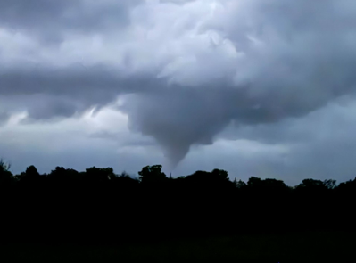
We received pictures shortly after the storm passed and there was an obvious funnel present in the photos, but the trees toward the ground made it hard to see if it was indeed in contact with the ground. That's what NWS survey crews were able to see in person this week when visiting the area.
The tornado started west of Holland Road and south of Oxford Pike and moved northeast. The NWS used a drone over the area and it revealed "broken branches and convergent swirls within crops along the wooded area," says the NWS report.
There was minor damage to a property near the intersection of Holland Road and Oxford Pike. There was an outbuilding that lost some roof panels. A home also had minor roof damage and the windows were blown out.
"The tornado entered an open field north of Oxford Pike, with tornadic swirls evident within the crops," says the NWS survey team.
That was the last observed sign of the tornado that they were able to find.

